Mars was half covered by an ocean
Using images from cameras on Mars orbiters, an international research team led by the University of Bern has discovered structures on Mars that are very similar to classic river deltas on Earth. These are traces of rivers that have deposited their sediments into an ocean. This shows that Mars was a "blue planet" around three billion years ago.
The existence of water on Mars is a central topic in planetary research. Previous studies have already provided evidence of oceans and rivers on Mars, indicating a once humid and possibly habitable environment. Evidence of former water and a possible ocean have also been discovered for the Valles Marineris – the largest canyon system on Mars, which stretches along its equator. These come, among other things, from discoveries of minerals that have been altered by water.
A research team from the University of Bern, in collaboration with the INAF – Osservatorio Astronomico di Padova, has now gained new insights into the geological past of Valles Marineris: Using high-resolution images from various Mars cameras, the researchers have found geomorphologic structures near the canyon system that resemble river deltas on Earth. These structures represent the mouth of a river into an ocean. The new study thus provides clear evidence of a coastline and consequently of an earlier ocean on Mars. The study was recently published in the journal npj space exploration.
Bernese Mars camera delivers high-resolution images
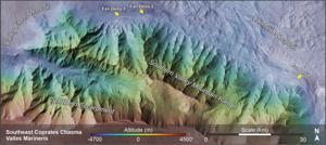
To investigate the geomorphological structures of Mars, the researchers used high-resolution images from various cameras on Mars probes, including the Bernese Mars camera CaSSIS (Colour and Stereo Surface Imaging System) on board the European Space Agency's ExoMars Trace Gas Orbiter, as well as data from the ESA space probes Mars Express and Mars Reconnaissance Orbiter. The investigation focused on the geomorphologic structures of the southeast Coprates Chasma, part of the Valles Marineris.
"The unique high-resolution satellite images of Mars have enabled us to study the Martian landscape in great detail by surveying and mapping," says Ignatius Argadestya, PhD student at the Institute of Geological Sciences and the Physics Institute of the University of Bern. Ignatius Argadestya is conducting research as part of the "Swiss Government Excellence Scholarship for Foreign Scholars (ESKAS)" at the University of Bern and is the first author of the study, which was produced as part of his dissertation. This was financially supported by the Swiss National Science Foundation and ESKAS.
"CaSSIS has been providing high-resolution color images of the surface of Mars since April 2018. The images are regularly used in scientific studies. I am personally very pleased that the images have now also been used in a geomorphological study by the Institute of Geological Sciences," says Nicolas Thomas, Professor at the Department of Space Research & Planetary Sciences (WP) at the University of Bern, under whose leadership the CaSSIS camera system was developed and built by an international team and which is funded by SERI's Swiss Space Office through ESA's PRODEX program (see info box).
River deltas as evidence of an earlier ocean on Mars
"When measuring and mapping the Martian images, I was able to recognize mountains and valleys that resemble a mountainous landscape on Earth. However, I was particularly impressed by the deltas that I discovered at the edge of one of the mountains," says Argadestya. At the lower end of the canyon system, so-called "scarp-fronted deposits" were discovered, which are interpreted as "fan deltas". Fan deltas form where a fan-shaped cone of debris and sand grows directly into a standing body of water. The researchers found that the structures mapped on Mars are very similar to classic deltas on Earth.
"Delta structures develop where rivers debouch into oceans, as we know from numerous examples on Earth," explains Fritz Schlunegger, Professor of Exogenous Geology at the Institute of Geological Sciences at the University of Bern. "The structures that we were able to identify in the images are clearly the mouth of a river into an ocean," Schlunegger continues. The study thus confirms and proves earlier scientific evidence that there was an ocean on Mars around three billion years ago.
An ocean as large as the Arctic Ocean
The results also show that the ocean found was at least as large as the Arctic Ocean on Earth. Schlunegger says: "We are not the first to postulate the existence and size of the ocean. However, earlier claims were based on less precise data and partly on indirect arguments. Our reconstruction of the sea level, on the other hand, is based on clear evidence for such a coastline, as we were able to use high-resolution images."
"With our study, we were able to provide evidence for the deepest and largest former ocean on Mars to date – an ocean that stretched across the northern hemisphere of the planet," says Argadestya. Today, wind-sculpted dunes cover the former delta structures. However, their original shape is still clearly recognizable.
Conditions on Mars could once have been favorable to life
The discovery of deltas and the confirmation of evidence of a former ocean suggest that conditions once prevailed on Mars that could have favored the emergence and development of life. "We know Mars as a dry, red planet. However, our results show that it was a blue planet in the past, similar to Earth. This finding also shows that water is precious on a planet and could possibly disappear at some point," emphasizes Argadestya.
"This project is particularly exciting for us researchers from the field of geology because it allows us to transfer concepts that we have developed from studies on Earth to other planets such as Mars," adds Schlunegger. "We used a sedimentological approach for this study, meaning we compared depositional environments between Earth and Mars." In a next step, the research group will now investigate the mineralogical composition of the ancient Martian soils. "Now that we know that Mars was a blue planet, we also want to know what kind of weathering took place there," concludes Argadestya.
Publication details:Argadestya, I., Schlunegger, F., Anselmetti, F.S. et al. Scarp-fronted deposits record the highest water level in Mars’ Valles Marineris. npj Space Explor. 2, 2 (2026). |
Institute of Geological SciencesThe Institute of Geological Sciences conducts internationally recognized basic research into the formation and development of the Earth as well as applied research into natural hazards, the supply of raw materials/energy and waste disposal. In order to identify and understand geological processes, researchers at the Institute of Geological Sciences use state-of-the-art methods and analytical equipment in well-equipped laboratories to study naturally occurring rocks and their components. The Bachelor's degree program in "Earth Sciences" offers students a combination of lectures, seminars, excursions and field work in a collegial atmosphere with individual supervision. In the subsequent Master's course in collaboration with the University of Fribourg, students can specialize in many different Earth science disciplines according to their interests and inclinations. More information |
Bernese space exploration: With the world’s elite since the first moon landingWhen the second man, "Buzz" Aldrin, stepped out of the lunar module on July 21, 1969, the first task he did was to set up the Bernese Solar Wind Composition experiment (SWC) also known as the “solar wind sail” by planting it in the ground of the moon, even before the American flag. This experiment, which was planned, built and the results analyzed by Prof. Dr. Johannes Geiss and his team from the Physics Institute of the University of Bern, was the first great highlight in the history of Bernese space exploration. Ever since Bernese space exploration has been among the world’s elite, and the University of Bern has been participating in space missions of the major space organizations, such as ESA, NASA, and JAXA. With CHEOPS the University of Bern shares responsibility with ESA for a whole mission. In addition, Bernese researchers are among the world leaders when it comes to models and simulations of the formation and development of planets. The successful work of the Space Research and Planetary Sciences Division (WP) from the Physics Institute of the University of Bern was consolidated by the foundation of a university competence center, the Center for Space and Habitability (CSH). The Swiss National Fund also awarded the University of Bern the National Center of Competence in Research (NCCR) PlanetS, which it manages together with the University of Geneva. |
Support of the SERI / Swiss Space OfficeCaSSIS is a project of the University of Bern and funded through the Swiss Space Office via the European Space Agency's PRODEX programme. The instrument hardware development was also supported by the Italian Space Agency (ASI), INAF/Astronomical Observatory of Padova, and the Space Research Center (CBK) in Warsaw. For all instruments developed in Switzerland, major contributions and/or partial deliveries come from Swiss industry. The PRODEX programme, under which scientific instruments or sub-systems are provided, requires industrial participation and thus promotes knowledge and technology transfer between universities and industry and gives Switzerland a structural competitive advantage as a business location – not least thanks to spill-over effects on other sectors of the participating companies. Swiss participation in ESA programmes enables Swiss players from science and industry to position themselves ideally in ESA activities in this field. More information on CaSSIS: https://www.cassis.unibe.ch/ |
12.01.2026